 Italy for me From Italy with love


Rome and its surroundings have a complex system of territorial divisions that began to take shape as early as the 6th century BC under the sixth king of Rome, Servius Tullius. He was the first to divide the city in relation to its hills into four districts:
- Suburan
- Esquiline
- Colline
- Palatine
In 7 BC, Augustus divided the now sprawling Ancient Rome into 14 districts or rioni (from the Latin regio – region) and appointed magistrates to oversee them, allowing the emperor to better manage the vast city. This administrative division remained in place until the 5th century AD.
With the fall of the Roman Empire, the city’s population decreased, and Rome gradually lost its former grandeur along with its official divisions.
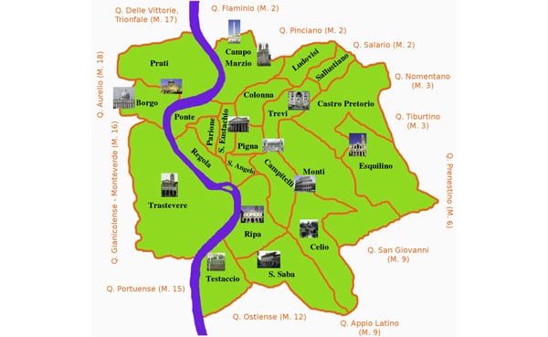
Throughout its long history, Rome’s rulers continually reorganized the city’s structure. Starting in the 12th century, districts began to reappear, featuring slightly different boundaries but still called rioni.
By the 12th century, there were 12 districts. In the 14th century, Trastevere was added, followed by Borgo in the 16th century, Esquilino in the 19th century, and by the 20th century, the total number reached 22.
We also recommend reading about the Monti district (rione Monti) in Rome.
Today, Rome is divided into 116 non-administrative units known as toponymic districts (comprensori toponomastici), which have developed historically:
- 22 rioni, mostly located within the Aurelian Walls (Mura Aurelian)
- 35 quarters (Quartieri di Roma) surrounding the historic center of Rome
- 6 suburbs (Suburbi di Roma) located outside the city
- 53 zones (Zone di Roma) in the rural areas of the municipality
An interesting fact: Since the 1920s, despite Rome’s expansion more than threefold, not a single new district has been given the rione designation.